Local Helene Response Information
| Sep 23 - Sep 30, 2024 All Day |
Use Caution After Storm Helene
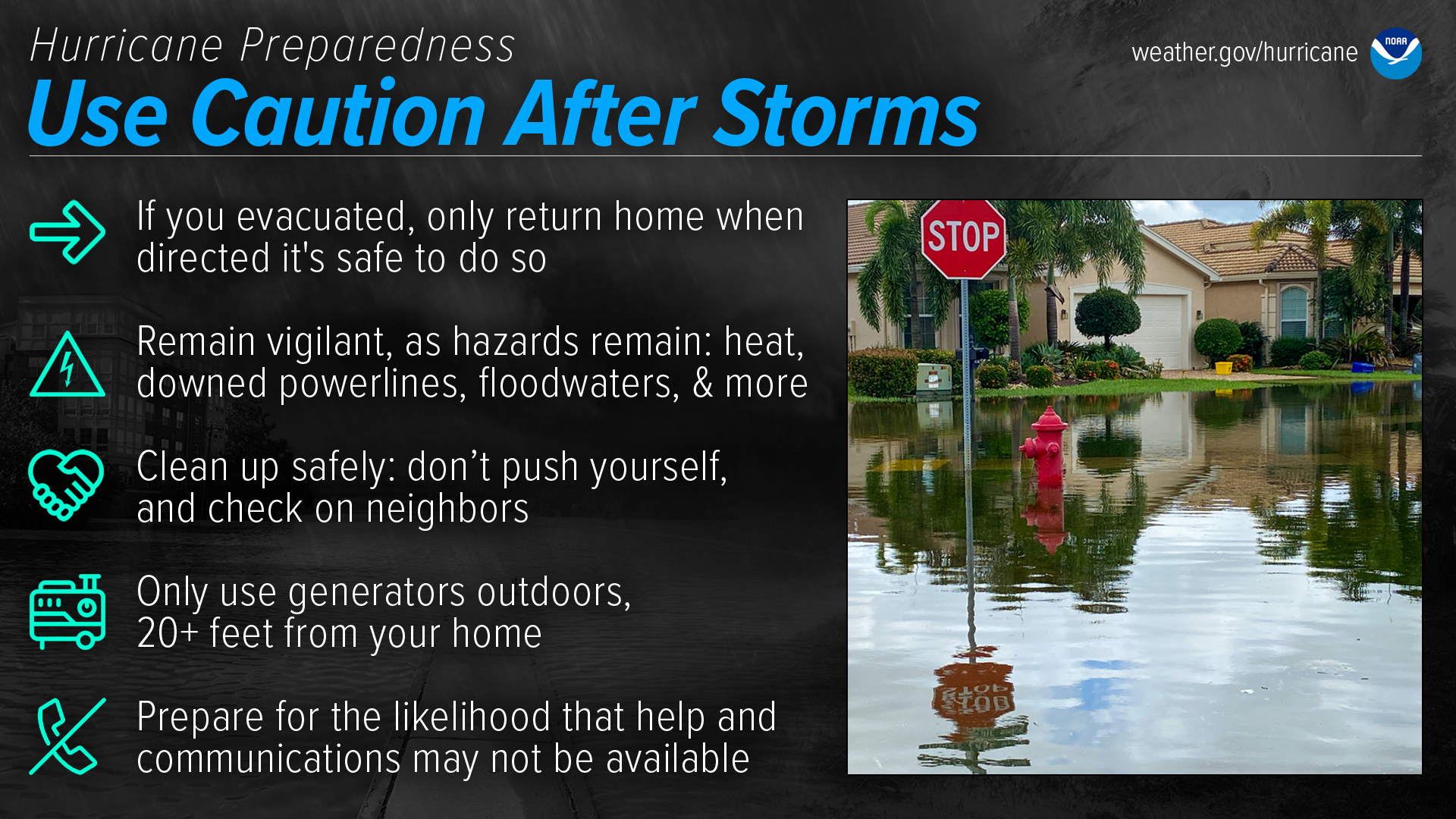
Dangers remain even after the skies turn blue. This is NOT the time to put your guard down. Nearly half of hurricane fatalities occur after the storm.
If you evacuated, only return home only when told to do so
Return home ONLY when officials say it is safe. Check with local officials both where you’re staying and back home before you travel.Remain vigilant, as hazards remain
- Be careful near damaged buildings. Walk carefully around the outside of your home to check for loose power lines, gas leaks, and structural damage, including dangerous debris such as nails or glass. Leave your home if there’s shifting or unusual noises. If you smell gas, get outdoors immediately and call 911.
- Avoid electric shock by staying far away from downed power lines. Stay alert: they may be on the ground, hidden in water, or dangling overhead.
- Flooded roads are very dangerous. It can be difficult to judge how deep or swift the water is moving — just 12 inches of water can float a car. Never drive through flooded roads, even if you are seeking supplies or trying to check on someone. Floods can also compromise bridges and roads. Avoid flooded river areas, as they can continue to rise long after a storm passes.
Don’t walk in floodwaters, either — they can contain harmful bacteria, chemicals, sharp objects, and dangerous animals.Clean up safely: don’t push yourself, and check on neighbors
Stay hydrated, wear light, loose-fitting clothing, and clean up during cooler hours if possible. Don’t push yourself: straining the body can lead to heart attacks, heat strokes, and other serious issues. Perform cleanups slowly, taking lots of breaks. Make sure to check on your elderly neighbors and other vulnerable people in your community. If your area is under a Heat Advisory, use extreme caution and consider cleaning up when the heat has subsided.Practice portable generator safety
Be very careful with portable generators: carbon monoxide poisoning is one of the leading causes of death in areas dealing with power outages. Never use a generator inside your home or garage, even if doors and windows are open. Only use generators outside, more than 20 feet away from your home, doors, and windows.Help and communications may not be readily available
After a hurricane, emergency responders may be overwhelmed. Be aware that it could take hours or days for them to reach your area. Communication systems may be impacted, and making phone or video calls might be difficult due to network congestion. If possible, communicate via text, email, or social media.
For The Latest Updates:
In St. Johns County:
![]() Follow St. Johns County Emergency Management:
Follow St. Johns County Emergency Management:
- Facebook & X / Twitter
 Sign up for Alert St. Johns notifications at SJCEmergencyManagement.com
 Register for Nixle Alerts—text StJohnsEOC to 888777
- Visit SJCFL.US/Hurricane
- Call the Citizen Information Hotline 904-824-5550
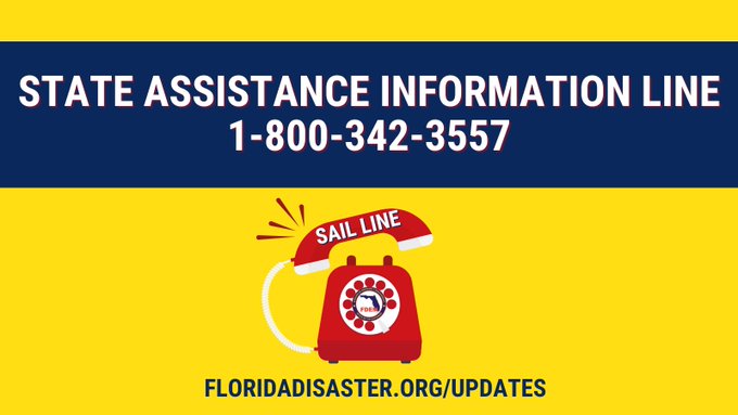
For the State of Florida:
![]() Florida Division of Emergency Management
Florida Division of Emergency Management
- HELENE UPDATES - Click Here
or Call the State Assistance Information Line 1-800-342-3557
📌 This toll-free hotline is activated to provide additional resources to help Floridians receive accurate & up-to-date information. During an emergency, the hotline is operational daily at set hours depending on the severity of the event.
School Closure information:
Boil Water Notices:
Helene Related News
September 27, 2024

September 26, 2024
DOH reminds residents that: Electrical Hazards Can Cause Burns, Shocks, and Potential Electrocution
- Always assume that all overhead wires are energized, or “live,” and at lethal voltages.
- Never touch a fallen overhead power line. If an overhead wire falls across your vehicle while you are driving, stay inside the vehicle and continue to drive away from the line.
- Never operate electrical equipment while you are standing in water or in the rain.
- Have a qualified electrician inspect electrical equipment that was made wet to ensure that no water remains within the unit.
Always report all fallen electrical lines
to your local utility provider.- Shared by St. Johns County Emergency Management:
Never drive through flooded roads. Just 6 inches of water can knock over an adult, and 12 inches can carry away a vehicle.
Driving through flooded roads can create a wake that damages nearby property.
Just 6 inches of water can knock over an adult, and 12 inches can carry away a vehicle.
Driving through flooded roads can create a wake that damages nearby property.

Health & Safety -
Before, During, and After the Storm
The Florida Department of Health urges residents and visitors to stay safe before, during, and after storm events with the following Health & Safety education and information:
- Boil Water Advisory Factsheet
- Carbon Monoxide Safety Factsheet
- Electrical Safety Factsheet
- Flood Water Safety Factsheet
- Food Safety Factsheet
- Mosquito Control Factsheet
- Pets and Wildlife Factsheet
- Private Well Water Factsheet
- Septic Tank Factsheet
National Hurricane Center: Helene

Image provided by:
National Hurricane Center
Hurricane and Other Tropical Storm Projected Paths
The source for portions of this content is the National Weather Service — National Oceanic and Atmospheric Administration (NOAA) - Hurricane Preparedness. For more information on the guidance above, visit Weather.gov.
Note: This page contains materials in the Portable Document Format (PDF). The free Adobe Reader may be required to view these files.- Schedule
- Resources
- Archive
24/7/365 Be Prepared
Emergency Preparedness For Special Needs Residents (PDF, 124KB)
Before The Storm Safety (PDF, 205KB)
After The Storm Safety (PDF, 359KB)
Centers for Disease Control and Prevention
Department of Homeland Security
September 26, 2024
Additional Resources
Remember, it only takes one storm to change your life and community. For more information on hurricanes and hurricane safety, visit:
- American Red Cross – Hurricane Preparedness
- CDC – Hurricanes and Other Tropical Storms
- DOH-St. Johns Emergency Preparedness and Response
- FloridaDisaster.org – Division of Emergency Management
- Hurricane Strong – Federal Alliance for Safe Homes
- National Hurricane Center
- National Hurricane Preparedness
- NOAA – Weather Radio
- NWS – Hurricane Safety Tips and Resources
- Ready.gov – Hurricanes
- St. Johns County Emergency Management
- St. Johns County Special Medical Needs Shelter
- Emergency Preparedness For Special Needs Residents
- Before The Storm Safety
- After The Storm Safety
Stay Informed this Hurricane Season
Receive alerts about emergencies by signing up for the
St. Johns County Emergency Notification System:
Additional Resources:
- Alert St. Johns—Emergency Notification System
- DOH-St. Johns Emergency Preparedness and Response
- FloridaDisaster.org – Division of Emergency Management
- National Hurricane Center
- NOAA Weather Radio
- St. Johns County Emergency Management
Understand Forecast Information
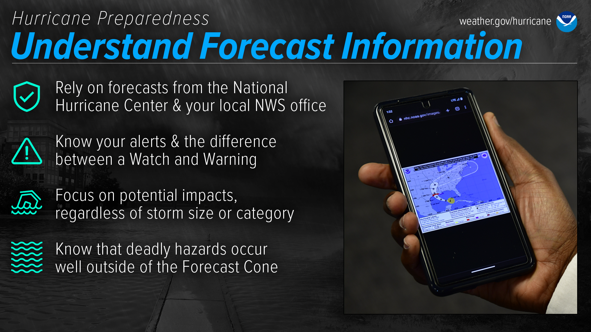
National Weather Service forecast products can tell you a lot about what is expected to happen with a storm, including the storm’s paths, rainfall amounts, wind speeds, and more. There is a lot of information available days ahead of a storm, and it is important to understand what it means.
Have trusted sources for storm information
Rely on official forecasts and well-established media partners in the Weather Enterprise. Be cautious of sensational headlines and instead look for reliable sources to determine a storm's potential impacts. Use the official National Hurricane Center Forecast — their hurricane specialists access a variety of data (models, aircraft, satellite) to make the most accurate forecasts possible. Meteorologists at local NWS offices understand which locations in your area are most vulnerable to storm surge, flooding, and wind. Always check to make sure you have the latest forecast information. Make sure to have Wireless Emergency Alerts enabled on your phone to receive Warnings.Know your alerts & the difference between a Watch & Warning
In general, a Watch means impacts are possible; a Warning means impacts are expected or happening. Different hazards and alerts require different responses:
- A Hurricane Watch means hurricane conditions are possible somewhere within the watch area, with tropical-storm-force winds beginning within the next 48 hours. Prepare by boarding up windows and moving loose items indoors, and make sure your emergency kit is ready. A Hurricane Warning means hurricane conditions are expected somewhere within the warning area, with tropical-storm-force winds beginning within 36 hours. Seek shelter in a sturdy structure or evacuate if ordered.
- A Tropical Storm Watch means tropical storm conditions are possible within the next 48 hours, a Tropical Storm Warning means they are expected somewhere within the warning area. Remember, a tropical system does not have to reach hurricane strength to be deadly.
- A Storm Surge Watch means the possibility of life-threatening inundation generally within 48 hours, and a Storm Surge Warning means the danger of life-threatening inundation generally within 36 hours. In either case, please promptly follow evacuation and other instructions from local officials.
- An Extreme Wind Warning means extreme hurricane winds (115 mph+) are imminent or happening: take immediate shelter in an interior portion of a well-built structure.
- A Flash Flood Warning means dangerous flash flooding is expected: move to higher ground, and never walk or drive through floodwater. A Flash Flood Emergency is issued for exceedingly rare situations when a severe threat to human life and catastrophic damage is happening or about to happen — do NOT attempt to travel unless you are under an evacuation order or your life is imminently at risk.
- A Flood Watch means flooding is possible: stay tuned to trusted news sources and be ready to seek higher ground. A Flood Warning means flooding is happening or about to happen: move to higher ground immediately.
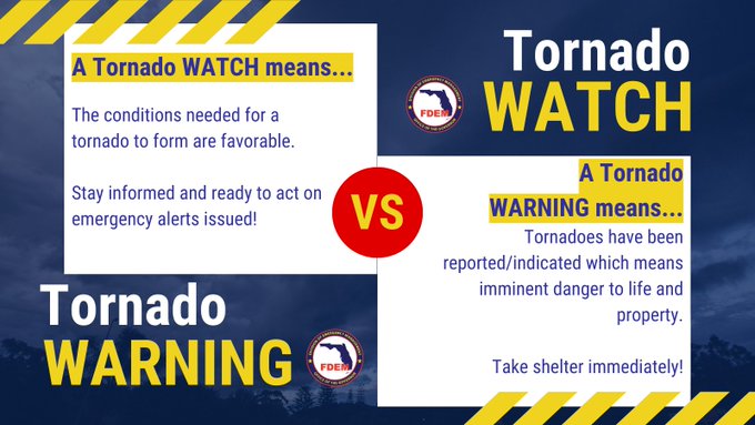
- A Tornado Watch means a tornado is possible: know your safe place and be ready to act quickly if a Warning is issued. A Tornado Warning means a tornado is happening or about to happen - immediately seek shelter in your safe place!
Focus on potential impacts regardless of storm size or category
Do not focus on a specific storm category; all hurricanes and tropical storms can bring life-threatening storm surge, inland flooding, and damaging winds. The storm's scale only tells you about the strongest winds near the center of the storm and does not tell you about potentially life-threatening flooding from storm surge or rain. Remain vigilant even if the winds have weakened and the storm becomes a lower category or tropical storm — rainfall and storm surge impacts often continue.Deadly hazards occur well outside of the cone
Impacts can be felt far from the storm's center, even well inland and outside the Forecast Cone. Remember: the storm itself can stretch well beyond the Forecast Cone, and so can the impacts.The National Hurricane Center Forecast Cone shows the probable forecast track of the center of the storm. This means that the storm’s center will probably travel somewhere within the cone’s boundaries. (Historically, the storm’s center has remained within the forecasted cone roughly two-thirds of the time.) The cone does NOT represent the size of the storm in any way.
Stay Protected During Storms
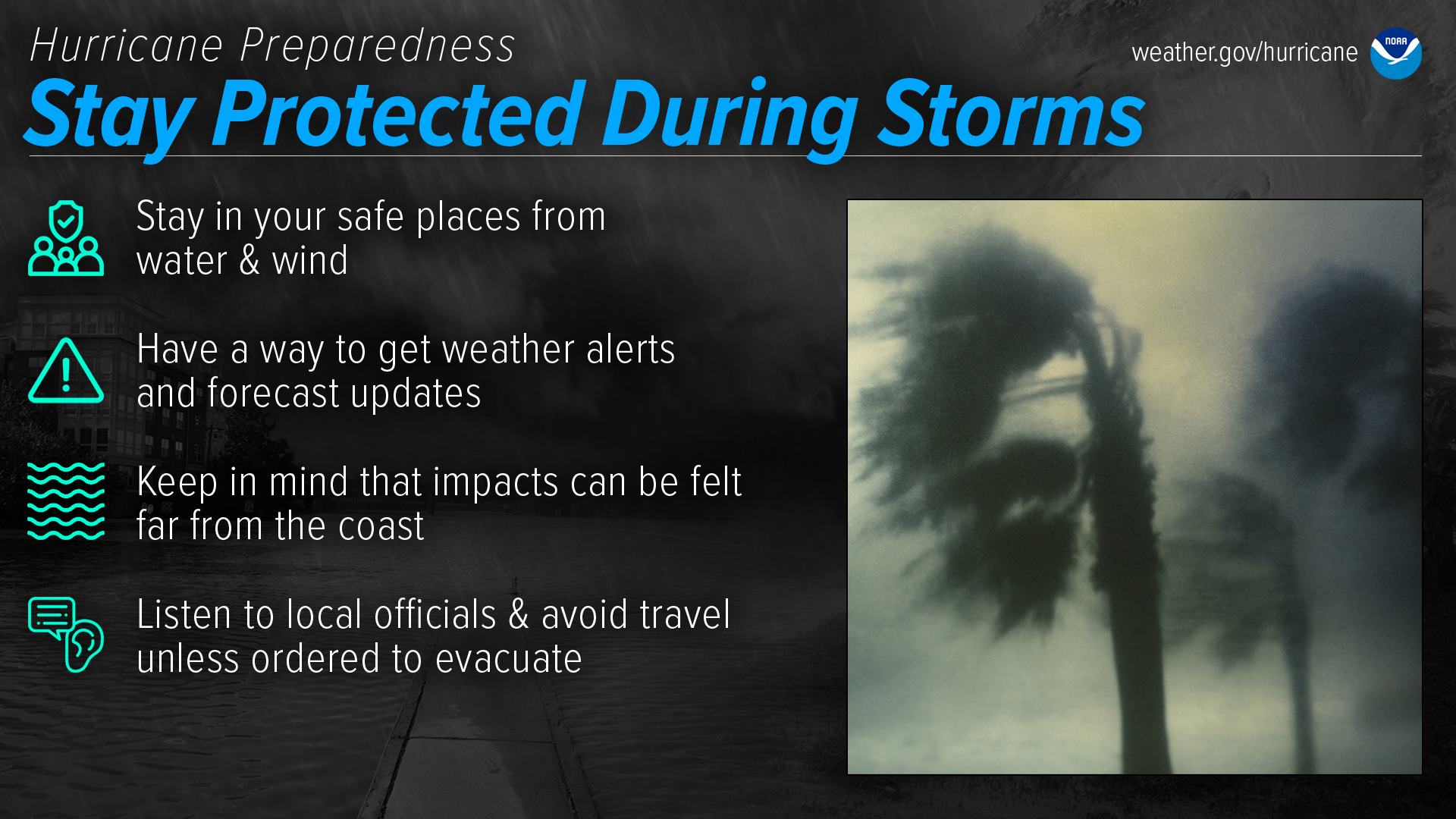
During a storm, whether you’ve evacuated or are sheltering in place, know what to expect from the hazards you may face. Remain vigilant, stay up-to-date with the latest forecasts and alerts, and continue to listen to local officials.
Stay in your safe places from water & wind
Always keep a safe distance from flooded and damaged areas. When you’re at risk from storm surge or flooding, it’s important to get to high ground away from bodies of water and any flood-prone areas. Evacuate if told to do so. Never drive through floodwaters or compromised bridges. Always pay attention to barriers and signage.If your house becomes flooded and you’re still there, get higher in your house to escape the flood waters. If the highest floor of your home becomes dangerous, get on the roof and call 911.
Though rain and storm surge cause more direct deaths, wind can also be very destructive and deadly in hurricanes. Winds can be stronger higher above ground level. This can put high-rise buildings at a greater risk. To protect yourself from wind, the best thing you can do is put as many walls as possible between you and the outside. An interior room without windows is the safest place you can be in a building. You can cover yourself with a mattress and wear a helmet for added protection. If your area is under an Extreme Wind Warning, take shelter immediately. Make sure to stay sheltered until the threat is gone.
Have a way to get weather alerts and forecast updates
Make sure to have Wireless Emergency Alerts enabled on your phone to receive Warnings and other alerts. Always pay attention to the latest forecast as conditions can change quickly and storms can rapidly intensify from a tropical storm to a major hurricane. Even small changes in the storm’s track can make a big difference.Keep in mind that impacts can be felt far from the coast
Remain vigilant even if you’re far from the most damaging winds. Inland flooding can be felt hundreds of miles from the coast. Never drive through floodwaters! A car can be swept away with only a foot of water, and there’s no way to know if the road itself has collapsed when hidden by water.Listen to local officials & avoid travel unless ordered to evacuate
Local officials can provide you with up-to-date information as the situation changes in your area. Evacuation orders may still be given at this late stage — leave immediately if ordered! Follow recommended evacuation routes — do not take shortcuts, as they may be blocked. Be alert for road hazards such as washed-out roads or bridges and downed power lines. Never drive through floodwaters.Boil Water Notices
Know when water is safe to use:
- Boil Water Notice(s)
- Text Only - Boil Water Notice(s) (low-bandwidth version)
Important information shared by
St. Johns County Emergency Management:
Thursday, September 26, 2024 7:47PM
(Shared via Facebook Feed)- Important message from our partners atUS National Weather Service Jacksonville Florida8 PM Update:

 Tornado Watch has been extended thorough 6 AM Friday morning.


- Important message from our partners atUS National Weather Service Jacksonville Florida
- St. Johns County Opening Storm Shelters at 8 a.m. Thursday, Sept. 26
St. Johns County is opening two storm shelters to the public at 8 a.m. on Thursday, Sept. 26, at the following locations ahead of potential impacts from Helene.- Solomon Calhoun Community Center – General Population and Pet Friendly Shelter
1300 Duval St., St. Augustine - St. Johns County Health and Human Services Building – Special Medical Needs Shelter
200 San Sebastian View, St. Augustine
Florida Special Needs Registry
While shelters provide safety throughout the storm, residents must bring supplies to maintain personal comfort. St. Johns County recommends that all evacuees bring their own bedding, including sleeping bags or air mattresses, pillows, sheets, and blankets. A five-day supply of water, non-perishable food, medication, diapers, and other personal items are also suggested. Please refer to the list below for additional supply suggestions.- At least a five-day supply of medications, insulin, and a cooler if you are diabetic
- Personal grooming and hygiene items, feminine supplies
- Extra clothing, eyeglasses
- Books, magazines, cards, games, etc.
- Pillows, blankets, sheets, lawn chair/chaise lounge
- Flashlight and extra batteries, manual can opener
- Personal identification/important papers
- Solomon Calhoun Community Center – General Population and Pet Friendly Shelter
- Governor Ron DeSantis Issues Updates on State Preparedness Efforts Ahead of Hurricane Helene
- Free Uber Rides (TO SHELTERS) in counties with declared states of emergency (Including St. Johns) using Promo Code' HeleneRelief ' (as one word, no spaces)
- Free Uber Rides (TO SHELTERS) in counties with declared states of emergency (Including St. Johns) using Promo Code' HeleneRelief ' (as one word, no spaces)
- St. Johns County has issued a Local State of Emergency as of 8 a.m. today (Wednesday, September 25) in preparation for Helene.
 A declaration of a state of emergency aids in storm response, recovery, and operations.
For questions, call the Citizen Information Hotline at 904-824-5550. It will be open until 5 p.m. today and will reopen tomorrow (Thursday, September 26) at 8 a.m.
- St. Johns County Opening Storm Shelters at 8 a.m. Thursday, Sept. 26
- US National Weather Service Jacksonville11am (9/26) Hurricane Helene Update: A Tornado Watch has been issued for all of NE FL & SE GA through tonight. Several tornadoes are possible, be sure to have multiple ways to receive warnings and know your safe place before you need it.

September 25, 2024

- Update from US National Weather Service Jacksonville
 9/25, 5 AM Update - Tropical Storm HeleneHelene is forecast to rapidly intensify today & Thursday as it accelerates across the Gulf of Mexico
 Preparations for Helene Should Be Completed Today!
 Outer rain bands will begin for our area This afternoon and eveningHelene will bring increasing hazards to our area, especially on
 Hurricane force winds are expected in the Suwannee Valley and portions of inland southeast GA, Tropical Storm force winds expected for the rest of northeast FLA Flash Flood Watch is in effect our entire region through Friday morningCoastal Flooding is possible around times of high tide for the Atlantic coast, Intracoastal Waterway and the St. Johns River Basin -
 1-3 ft of storm surge flooding possible, especially around times of high tide.
 Dangerous boating & surf conditions -
 High risk of rip currents at all area beaches through at least Thursday eveningMonitor the latest forecast for Helene at hurricanes.gov and remain aware of our local threats and impacts at https://www.weather.gov/srh/tropical?office=jax
September 24, 2024
St. Johns County Emergency Management:
(Via Facebook Feed)
St. Johns County officials are urging all residents to take action ahead of possible tropical storm conditions. Check out the St. Johns County Emergency Management Hurricane Preparedness Guide: SJCEmergencyManagement.com and at any St. Johns County Public Library branch Know your evacuation zone: sjcfl.us/services-and-information/know-your-zone Make a disaster planStock up on your Disaster Supply Kit
Key items for your kit:
• Food & water for family & pets
• First Aid supplies & medications
• Emergency equipment (radio, batteries, chargers, flashlights)
• Cash & important documents Don't forget your pets!
If evacuation is ordered, make sure your pet’s kit includes:
• Food & water
• Medications & vaccination records
• ID collars, leashes, & carriers
Stay informed: Follow St. Johns County Emergency Management on Facebook & X/Twitter. Sign up for Alert St. Johns notifications at SJCEmergencyManagement.com Register for Nixle Alerts—text StJohnsEOC to 888777
FL Division of Emergency Management @FLSERT
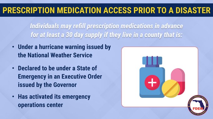
 Under EO 24-209, residents who rely on prescription medication can get early refills regardless of typical limits. If you're in a county under a State of Emergency for Tropical Storm #Helene, the time is NOW to utilize early prescription refill access.
Today, Governor Ron DeSantis issued Executive Order (EO) 24-209, Emergency Management – Amending Executive Order 24-208– Potential Tropical Cyclone Nine, increasing the number of counties in the state of Florida under a state of emergency to 61 ahead of the storm. Read the full executive order here.
- From our partners at US National Weather Service Jacksonville Florida:
 Update for Potential Tropical Cyclone #9
Impacts are increasing and becoming more likely, especially along the I-75 corridor, Thursday.
If you haven't, please begin to consider preparations today. Please pay close attention to forecast updates!

Free Sandbags
Tuesday, September 24, Noon - 5:00 P.M.
Wednesday, September 25, 8 A.M. - 5 P.M.
Sandbag Pickup Locations:- Windswept Acres Park - 5335 SR A1A South, St. Augustine
- Solomon Calhoun Center - 1300 Duval Street, St. Augustine
- County Equestrian Center - 8200 Smith Road, Hastings
- Mills Field - 1805 Racetrack Road, St. Johns
- North Beach Park - 3721 Coastal Highway, Vilano Beach
- Palm Valley Bridge - East Side of Intracoastal Waterway

FEMA Urges Gulf Coast Residents and Visitors to Prepare Now Ahead of Potential Major Storm
- WhiteHouse.gov: President Joseph R. Biden, Jr. Approves Florida Emergency Declaration
September 23, 2024
- St. Johns County Emergency Management:
From our partners at NWS US National Weather Service Jacksonville Florida Potential Tropical Cyclone Nine is expected to organize and strengthen moving into the Gulf of Mexico by Wednesday. Threats to our area could begin as early as Thursday.
Primary threats at this time will be strong to possibly damaging winds , life threatening rip currents, and dangerous small craft conditions. Heavy rainfall and isolated tornadoes are also a potential hazard.Continue to stay up to date with the latest advisories and forecast at nhc.noaa.gov
 - Today, Governor Ron DeSantis issued Executive Order (EO) 24-208, Emergency Management – Potential Tropical Cyclone Nine, declaring a state of emergency in 61 Florida counties ahead of the storm. To read the full executive order, click here.
Attorney General Moody Activates Price Gouging Hotline Following Declared State of Emergency for Potential Tropical Cyclone Nine. (866) 966-7226
 Download the
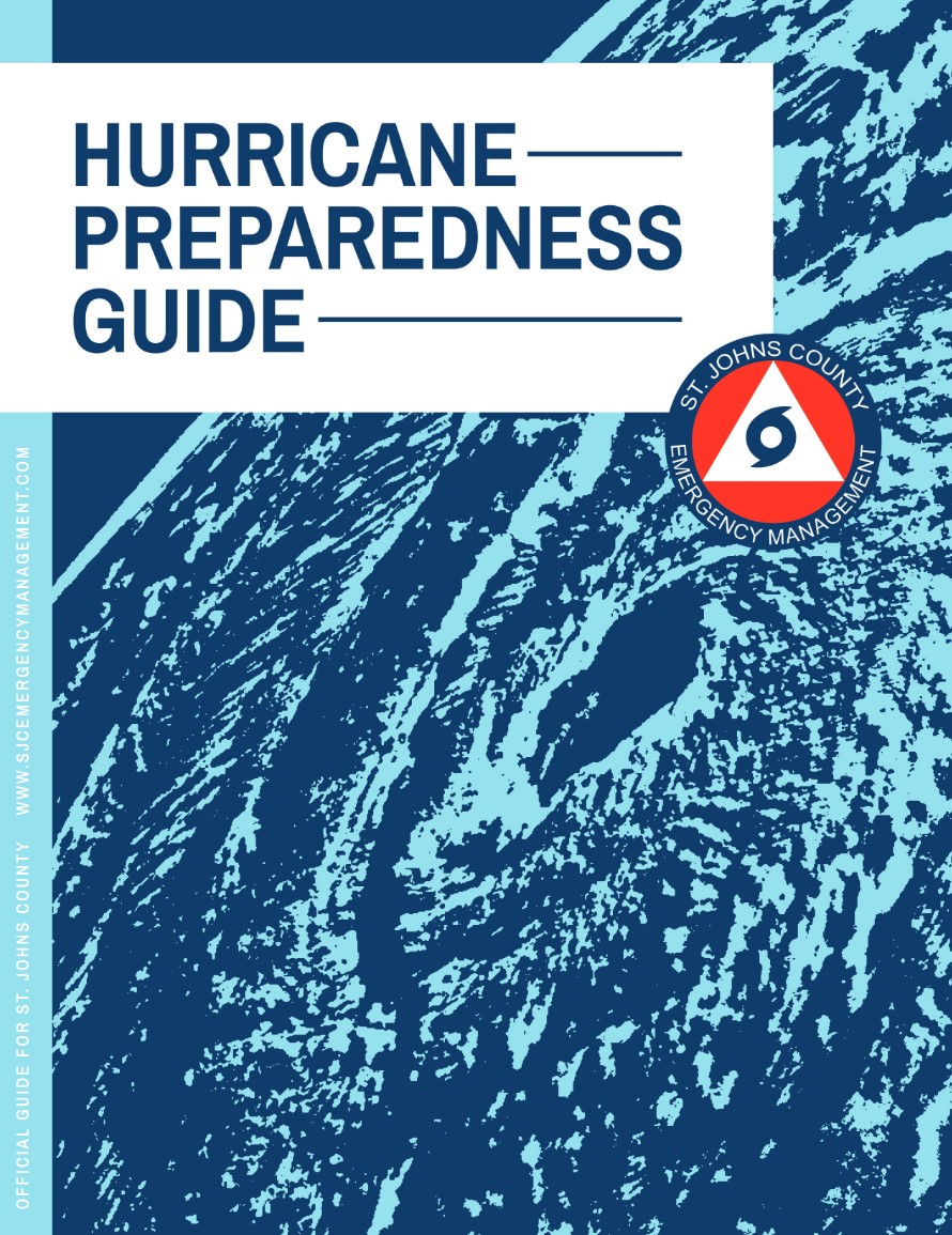
2024 St. Johns County
Hurricane Preparedness Guide
(PDF, 15.5MB)
Additional Downloads:
Please visit DOH-St. Johns — Hurricane Resources to find out more about hurricane preparedness resources in St. Johns County.
Be Prepared Before the Storm
The Florida Department of Health supports local and state responses to public health needs resulting from hurricanes, tropical storms, and other severe weather conditions.
Remember that severe weather can impact your access to power and water. Driving might not be possible after the storm - your car might be damaged and roads may be flooded or blocked.
- Prepare any supplies you may need to keep your loved ones safe and healthy before and after the storm.
- Listen to local authorities regarding evacuations. Don’t return home until local officials notify you it’s safe to do so.
Get Moving When a Storm Threatens

When a storm is forecast to impact your area, take action immediately to be ready. Ideally, longer-term preparedness actions such as having disaster supplies and an evacuation plan will have already been done before hurricane season, when the stores are stocked and time is on your side. When a storm threatens, there’s a lot more to do.
Protect your home
While longer-term home improvement needs to be done well ahead of time, when a storm threatens there are short-term actions to help protect your property. Board up windows, secure loose outdoor items, and secure all exterior doors. Move your vehicle to a safe location if you’re not using it to evacuate. If you are evacuating, unplug electrical equipment such as radios, televisions and small appliances (freezers and refrigerators also need to be unplugged if there is a risk of flooding). If you are instructed to do so, shut off water, gas and electricity before leaving.Determine sheltering options & consider your pets
Check with local officials to find out what shelter spaces are available. If you have pets, find a place where they can stay — most public shelters only allow service animals. In general, have multiple sheltering options, including distant ones such as a friend’s home outside of the impact area, or a motel. Depending on the circumstances, your home may need to be your shelter — make sure it is prepared and that you know the safest places inside.Ready your go-bag, medications & supplies, charge phone, fill up/charge vehicle
Have a go bag ready to take things with you if you need to leave in a hurry. In addition to basic survival needs, don’t forget other supplies such as chargers and hygiene products. Plan to have enough for at least three days, and don’t forget about your pets. While preparing these basic needs, don't forget to keep your phone charged, and make sure to fill up/charge your vehicle as well.
Your go-bag should also contain important personal and property documents, including your written communication plan.Help your neighbors, especially the elderly & other vulnerable people
Many people rely on their neighbors before and after a disaster, and there are many ways you can help them. Help them prepare for a storm, and help them evacuate if needed. Share the latest forecast information with your community so that they know what to expect.Follow evacuation orders if given
Always follow evacuation orders from local authorities — don’t wait for a hurricane to intensify before deciding to follow the order. You want to leave early enough to avoid being trapped by severe weather. If time allows, unplug electrical equipment, leave a note detailing your whereabouts, and check to see if any neighbors need a ride.
Know Your Risk: Water & Wind

Find out today what types of wind and water hazards could happen where you live. Hurricanes are not just a coastal problem. Impacts from wind and water can be felt hundreds of miles inland, and significant impacts can occur regardless of the storm’s strength. Know if you live in an area prone to flooding, if you live in an evacuation zone, and identify any structural weaknesses in your home.
Consider Your Threats
While hurricanes pose the greatest threat to life and property, tropical storms and tropical depressions also can be devastating. The primary hazards from tropical cyclones (which include tropical depressions, tropical storms, and hurricanes) are storm surge flooding, inland flooding from heavy rains, destructive winds, tornadoes, and high surf and rip currents.
- Storm surge is water that is pushed toward the shore by winds swirling around the storm, and historically has caused the largest loss of life in hurricanes. This rise in water level can cause severe flooding in coastal areas, which can submerge entire areas, cause structural damage to buildings, and wash out roads. Storm surge can travel several miles inland, especially along bays, rivers, and estuaries.
- Flooding from the extreme amounts of rain a hurricane can bring has also proven to be very deadly, both over an extended period of time as well as very short-term flash flooding. Homes and businesses could flood, and flooded roads could make travel and evacuations difficult, as well as being a potentially deadly hazard to those in vehicles or on foot. Floodwaters can also contain harmful bacteria, chemicals, wildlife and other dangerous objects. Extreme rain from hurricanes can even flood areas that aren’t normally prone to flooding. Flooding can happen hundreds of miles inland, and can persist for several days after a storm.
- Hurricane-force winds can cause damage to homes and other buildings, ranging from moderate to catastrophic depending on both wind speed and structural integrity. Wind damage can lead to large areas with power and communications outages, as well as uproot trees and make roads impassable due to debris. Signs, roofing material, and other items left outside can become flying missiles during hurricanes. Mobile homes are especially vulnerable to wind damage.
- Hurricanes and tropical storms can also produce tornadoes. These tornadoes most often occur in thunderstorms embedded in rain bands well away from the center of the hurricane; however, they can also occur near the eyewall.
- Waves from distant storms can produce deadly rip currents and rough surf on beaches very far away. Good weather at the beach itself does NOT mean the ocean is safe. Even storms more than 1,000 miles away can cause impacts.
Determine if you live in a flood-prone area
Anyone living in a flood-prone area is especially vulnerable to hurricane impacts. Find out today the flood risk for your area and plan accordingly. If you don’t live in a flood zone, that doesn’t necessarily mean you’re safe - extreme rain from hurricanes can bring floods even to areas that aren’t prone to flooding.Find out if you live in an evacuation zone
Determine if you live in a storm surge evacuation zone. This can tell you about your vulnerability to storm surge, and will be imperative when it comes time to develop an evacuation plan.
- HurricaneStrong: Find Your Evacuation Zone
Identify your home’s structural risks
Find out if your home has any weaknesses that could prove deadly in a hurricane. Are your exterior doors and garage door hurricane proof? Do you have storm shutters? Some aspects of your home can be strengthened to help withstand hurricane impacts, and some can not. Mobile homes are especially vulnerable to hurricane-force winds, and basements are especially vulnerable to storm surge and flooding.Additional Resources:
Prepare Before Hurricane Season
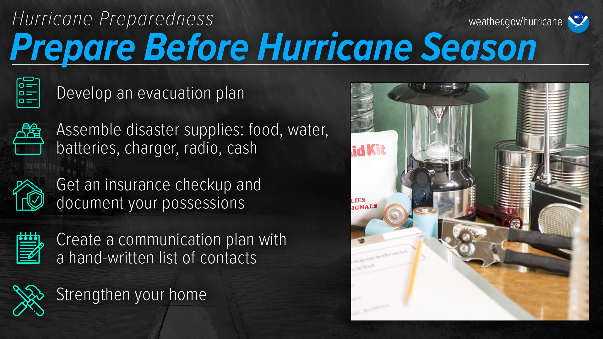
The best time to prepare is before hurricane season begins. Avoid having to rush through potentially life-saving preparations by waiting until it’s too late. Get your disaster supplies while the shelves are still stocked, and get that insurance checkup early, as flood insurance requires a 30-day waiting period.
Develop an evacuation plan
If you are at risk from hurricane impacts, you need an evacuation plan. Now is the time to begin planning where you would go and how you would get there. You do not need to travel hundreds of miles. Your destination could be a friend or relative who lives in a well built home outside flood prone areas. Plan several routes. Be sure to account for your pets.If you don’t have a vehicle, check with local officials to see what transportation options they may have available.
- Ready.gov: Evacuation
- FLASH: Find Your Evacuation Zone
- Weather.gov Video: Evacuation Plan (Length 1:20)
Assemble disaster supplies
Whether you’re evacuating or sheltering-in-place, you’re going to need supplies not just to get through the storm but for the potentially lengthy and unpleasant aftermath. Have enough non-perishable food, water and medicine to last each person in your family a minimum of 3 days (store a longer than 3-day supply of water, if possible). Electricity and water could be out for weeks. You’ll need extra cash, a battery-powered radio and flashlights. You may need a portable crank or solar-powered USB charger for your cell phones. And lastly, don’t forget your pets!
- FEMA: Build a Kit
- FLASH: Build A Disaster Supply Kit
- Ready.gov: Prepare Your Pets for Disasters
- Weather.gov Video:Hurricane Supplies(Length 1:26)
Get an insurance checkup & document your possessions
Call your insurance company or agent and ask for an insurance check-up to make sure you have enough insurance to repair or even replace your home and/or belongings. Remember, home and renters insurance doesn’t cover flooding, so you’ll need a separate policy for it. Flood insurance is available through your company, agent, or the National Flood Insurance Program at floodsmart.gov. Act now, as flood insurance requires a 30-day waiting period.Take the time before hurricane season begins to document your possessions: photos, serial numbers, or anything else that you may need to provide your insurance company when filing a claim.
- FLASH Insurance: Get a Checkup. Create an Inventory.
- Find flood insurance at floodsmart.gov
- WIN THIS HURRICANE SEASON: When there's a hurricane, luck is a plan that doesnt hold water. Learn how to bounce back from flood loss.
- FloodSmart.gov Video: Flood Insurance (Length 1:30)
Create a communication plan
Take the time now to write down your hurricane plan, and share it with your family. Determine family meeting places, and make sure to include an out-of-town location in case of evacuation. Write down on paper a list of emergency contacts, and make sure to include utilities and other critical services — remember, the Internet may not be accessible during or after a storm.
- FEMA: Make a Plan
- FLASH: Family Disaster Plan
- FEMA Mobile App & text for Shelter
- FEMA Video: Important Things To Know Before a Disaster
Strengthen Your Home
Now is the time to improve your home’s ability to withstand hurricane impacts. Trim trees. Install storm shutters, accordion shutters, and/or impact glass. Seal outside wall openings. Remember, the garage door is the most vulnerable part of the home, so it must be able to withstand hurricane-force winds. Many retrofits are not as costly or time consuming as you may think. If you’re a renter, work with your landlord now to prepare for a storm.And remember - now is the time to purchase the proper plywood, steel or aluminum panels to have on hand if you need to board up the windows and doors ahead of an approaching storm.
FEMA: Tips to Prepare Your Home for Hurricane Season
FLASH video: Protect Your Home from Flood Damage
Weather.gov Video: Strengthening Home (Length 1:36)
Take Action Today
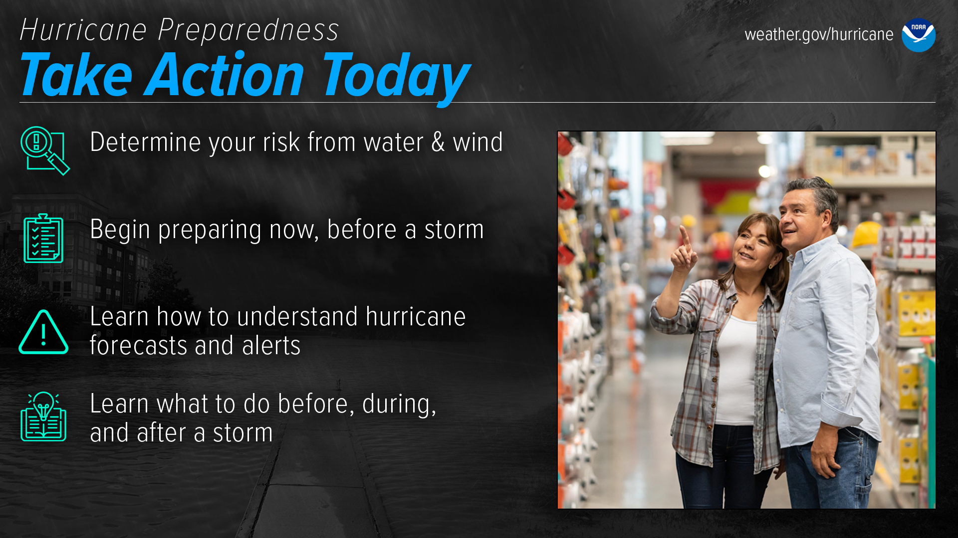
Are you ready for hurricane season? Take action TODAY to be better prepared for when the worst happens. Understand your risk from hurricanes, and begin pre-season preparations now. Make sure you understand how to interpret forecasts and alerts, and know what to do before, during, and after a storm. Even if you are already well-prepared and knowledgeable, there may be additional things you could do or learn to be even more prepared.
Download the
2024 St. Johns County
Hurricane Preparedness Guide
(PDF, 15.5MB)
Please visit Florida Department of Health in St. Johns County — Hurricane Resources to find out more about hurricane preparedness resources in St. Johns County.
Featured Programs

Connect with DOH